News for BC Environment & Climate Monday, Oct. 5, 2026
FEATURE · EL NIÑO 2026-27
Near-record El Niño puts B.C. on watch for a thin snowpack and a dry 2027
Forecasters say the Pacific warm-up now under way could rival or exceed the strongest events since 1950. Here is what the science says, and doesn't say, about B.C.'s water, power, farms, forests, fish and ski hills.
VANCOUVER — For the second time in three years, British Columbians are being told to brace for an El Niño winter. This time, forecasters say, it may be the strongest one on modern record.
The U.S. National Oceanic and Atmospheric Administration's Climate Prediction Center (CPC) said in its Sept. 10 update that there is a greater than 90 per cent chance of a "very strong" El Niño through the fall and winter of 2026-27, and a 75 per cent chance that, by October to December, it will exceed every El Niño measured since 1950. Australia's Bureau of Meteorology, the World Meteorological Organization (WMO) and Environment and Climate Change Canada (ECCC) are all saying much the same thing.
For B.C., the main risk is not a single storm. It is a slow one: a mild, possibly dry winter that leaves too little snow in the mountains, followed by an early melt, low rivers and another tough fire season in 2027. The province goes into that winter already short of water. Drought levels in parts of the Southern Interior remain elevated after a summer of crop losses, fish-protection orders and evacuations.
None of this is guaranteed. "Super El Niño does not necessarily mean it will have a huge impact on Canada," ECCC physical scientist Marko Markovic said in September. "It might, but it might not." But the odds are tilted, and the agencies that manage B.C.'s water, power and forests are already planning around them.
What El Niño is, and where this one stands
El Niño is the warm phase of a natural Pacific cycle. The trade winds that normally push warm water toward Asia weaken or reverse, warm water spreads east, and the shift in tropical rainfall moves the jet streams that steer weather worldwide. Events typically recur every two to seven years and peak between November and February, according to the WMO.
Forecasters track it with sea-surface temperatures in the "Niño-3.4" box of the central equatorial Pacific. Those numbers are now exceptional:
- NOAA weekly data show the Niño-3.4 anomaly reached +3.2°C in the week centred on Sept. 30, 2026, the highest weekly value in the agency's satellite-era series going back to 1981. The previous weekly high, during the 2015 El Niño, was +3.0°C.
- NOAA's three-month Oceanic Niño Index (ONI) for July to September 2026 was +2.16°C, already above the +2.0°C level usually called "very strong."
- The Bureau of Meteorology reported a relative Niño-3.4 value of +2.51°C for the week ending Sept. 13 and said most models forecast a peak above +3.0°C.
- The WMO said Sept. 3 that its forecasting centres put the chance of El Niño lasting through February 2027 at "nearly 100%," the first time one of its updates has been "so unequivocal."
FIGURE 1 · THE PACIFIC TODAY
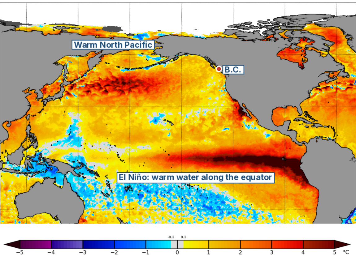
Sea-surface temperature anomalies (°C versus normal) on Oct. 4, 2026. The dark red band along the equator is El Niño. Much of the North Pacific, including waters off B.C., is also warmer than normal. Source: NOAA Coral Reef Watch, Daily 5km SST Anomalies (v3.1), Oct. 4, 2026 (U.S. government work, public domain). Cropped to the Pacific; labels added by News for BC.
One wrinkle matters for comparisons. Because the whole tropical ocean has warmed, NOAA, the BoM and ECCC are increasingly using a relative index (RONI) that subtracts that background warming. On that measure, the July-September value was +1.69°C. NOAA's median forecast for October to December is +2.67°C, with a 90 per cent range of +2.12°C to +3.23°C. A value of +2.5°C or more would make this the strongest event since 1950. Either way you measure it, scientists say it will be historic.
FIGURE 2 · NOAA'S OFFICIAL ODDS
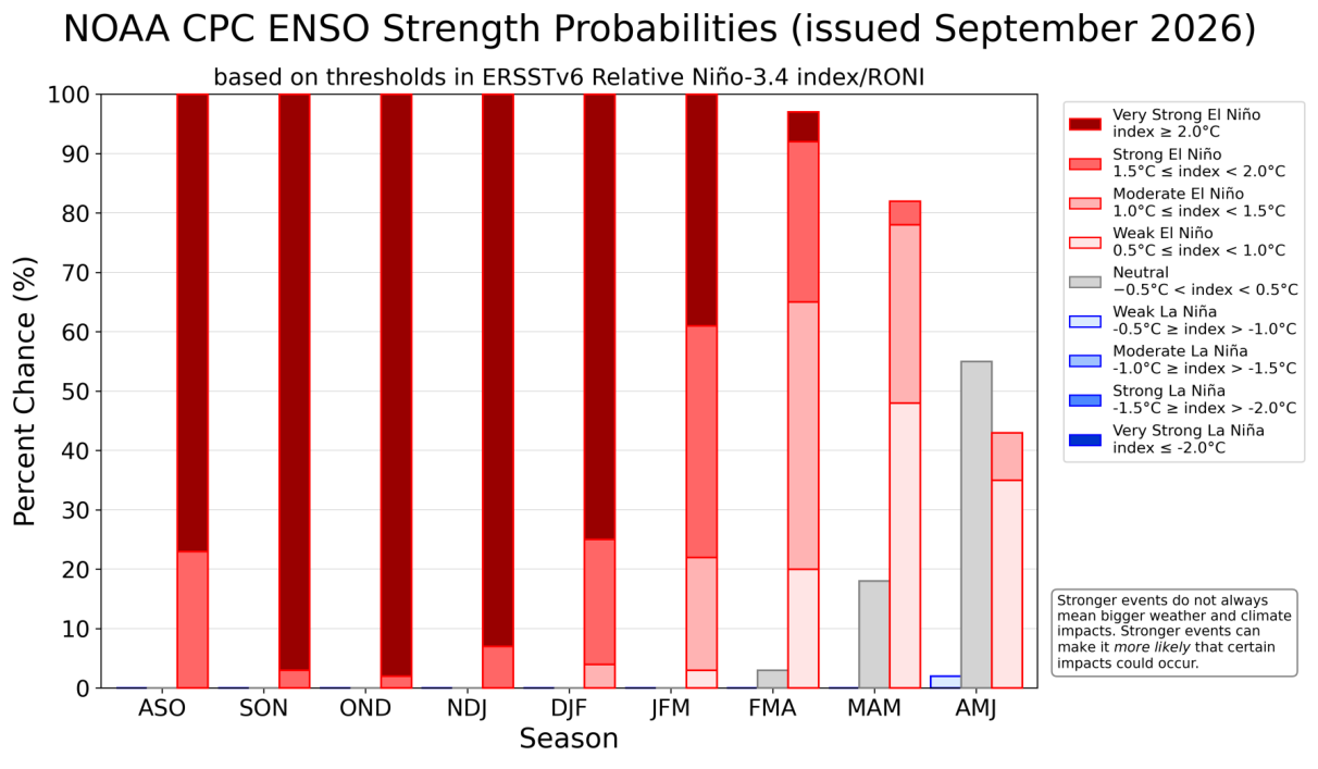
Chance of each El Niño strength category by three-month season, issued Sept. 10, 2026. Dark red is a "very strong" event (relative index of 2.0°C or more). NOAA puts those odds near 100 per cent through November–January, easing in late winter, with neutral conditions most likely by April–June 2027. Source: NOAA Climate Prediction Center, ENSO Strength Probabilities (issued September 2026) (U.S. government work, public domain).
The extra ocean heat is also pushing up global temperatures. The European Copernicus Climate Change Service (C3S) reported that August 2026 averaged 16.96°C globally, the warmest August in its records and effectively tied with July 2023 (16.95°C) as the warmest month ever measured. NOAA's National Centers for Environmental Information ranked it the warmest August in 177 years of records. ECCC's Canadian Centre for Climate Services says a very strong El Niño makes it "highly likely" that 2027 will become the hottest year on record.
The record: what past big El Niños did here
The three "very strong" events since 1950, plus the strong 2023-24 event, give B.C. a rough playbook.
1982-83. One of the strongest events of the century. Warm coastal water changed how Fraser River sockeye came home. Published fisheries research found that about 80 per cent returned through Johnstone Strait, north of Vancouver Island, rather than the usual route through Juan de Fuca Strait.
1997-98. By Jan. 1, 1998, the River Forecast Centre estimated the Kootenay snowpack at about 39 per cent below normal and the Okanagan-Similkameen-Kettle region at about 40 per cent below. Some of that gap later closed. The following summer, lightning on July 29, 1998 started the Silver Creek fire near Salmon Arm, which forced evacuations amid extreme drought and heat.
2015-16. This event shows why a near-normal snowpack can still mislead. The provincial snowpack was 91 per cent of normal on April 1, 2016. An extremely warm April then melted it so fast that the May 1 average fell to 53 per cent, a record low in data going back to 1980.
2023-24. El Niño was building during B.C.'s record 2023 fire season, when 2.84 million hectares burned, according to the BC Wildfire Service. Most of that season's drought, however, came before El Niño's winter effects arrived. That winter, Canada had its warmest on record, 5.2°C above the 1961- 1990 baseline according to ECCC. By April 1, 2024, B.C.'s snowpack averaged 63 per cent of normal, which the River Forecast Centre called the lowest "since 1970, at least." Even so, a deep freeze from Jan. 11 to 15, 2024 wiped out an estimated 97 to 99 per cent of the Interior's wine-grape crop, a reminder that a mild winter can still bring a damaging cold snap.
FIGURE 3 · HOW THIS EVENT COMPARES
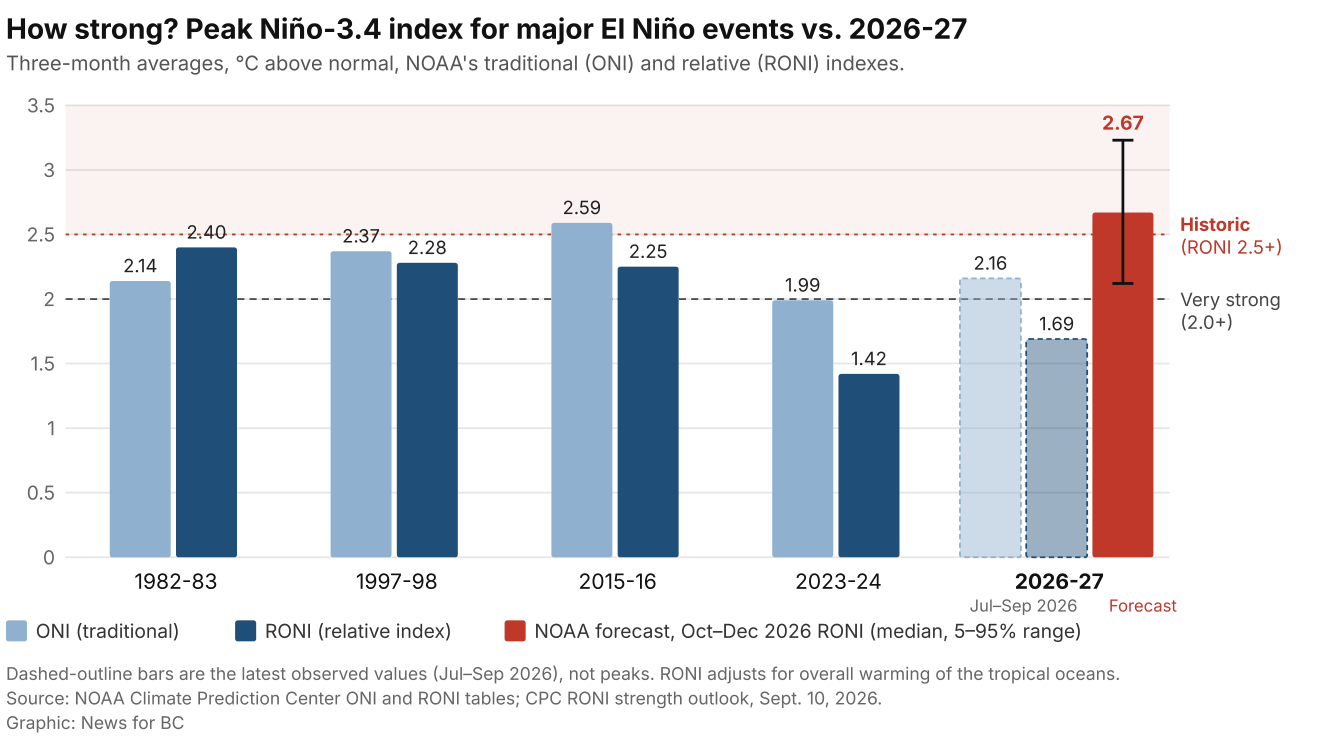
Peak three-month Niño-3.4 values for the strongest El Niños since 1950 and the 2023-24 event, against the latest 2026 readings and NOAA's October–December forecast. Source: NOAA Climate Prediction Center ONI and RONI tables; CPC RONI strength outlook, Sept. 10, 2026. Graphic: News for BC.
| El Niño event | Peak ONI (°C) | Peak RONI (°C) | What B.C. saw |
|---|---|---|---|
| 1877-78 | n/a (reconstructed Niño-3.4 ≈ 2.5–3.2 ± 0.6) | n/a | No B.C. snow records; global famine |
| 1982-83 | 2.14 | 2.40 | ~80% of Fraser sockeye diverted north via Johnstone Strait (1983) |
| 1997-98 | 2.37 | 2.28 | Jan. 1, 1998 snowpack ~39–40% below normal in Kootenay and Okanagan; Silver Creek fire, summer 1998 |
| 2015-16 | 2.59 | 2.25 | April 1 snowpack 91%; May 1 record-low 53% after fast melt |
| 2023-24 | 1.99 | 1.42 | April 1 snowpack 63%, lowest since at least 1970; record-warm Canadian winter |
| 2026-27 (so far) | 2.16 (Jul–Sep) | 1.69 (Jul–Sep); Oct–Dec forecast 2.67 | Starts with Southern Interior drought; April 1, 2026 snowpack 92% |
Sources: NOAA CPC ONI and RONI data files; Huang et al. (2020); B.C. River Forecast Centre snow bulletins; DFO-referenced sockeye diversion research; ECCC.
The typical El Niño winter in B.C.
ECCC research summarized by the Canadian Centre for Climate Services in August finds that El Niño "tends to cause milder winters with less snow and warmer, drier springs in western, northwestern and central Canada." In the last three very strong events, much of B.C. had a dry winter. Parts of the coast, however, were wetter, and in 1997-98 record rainfall damaged the Trans-Canada Highway.
FIGURE 4 · THE TYPICAL EL NIÑO WINTER
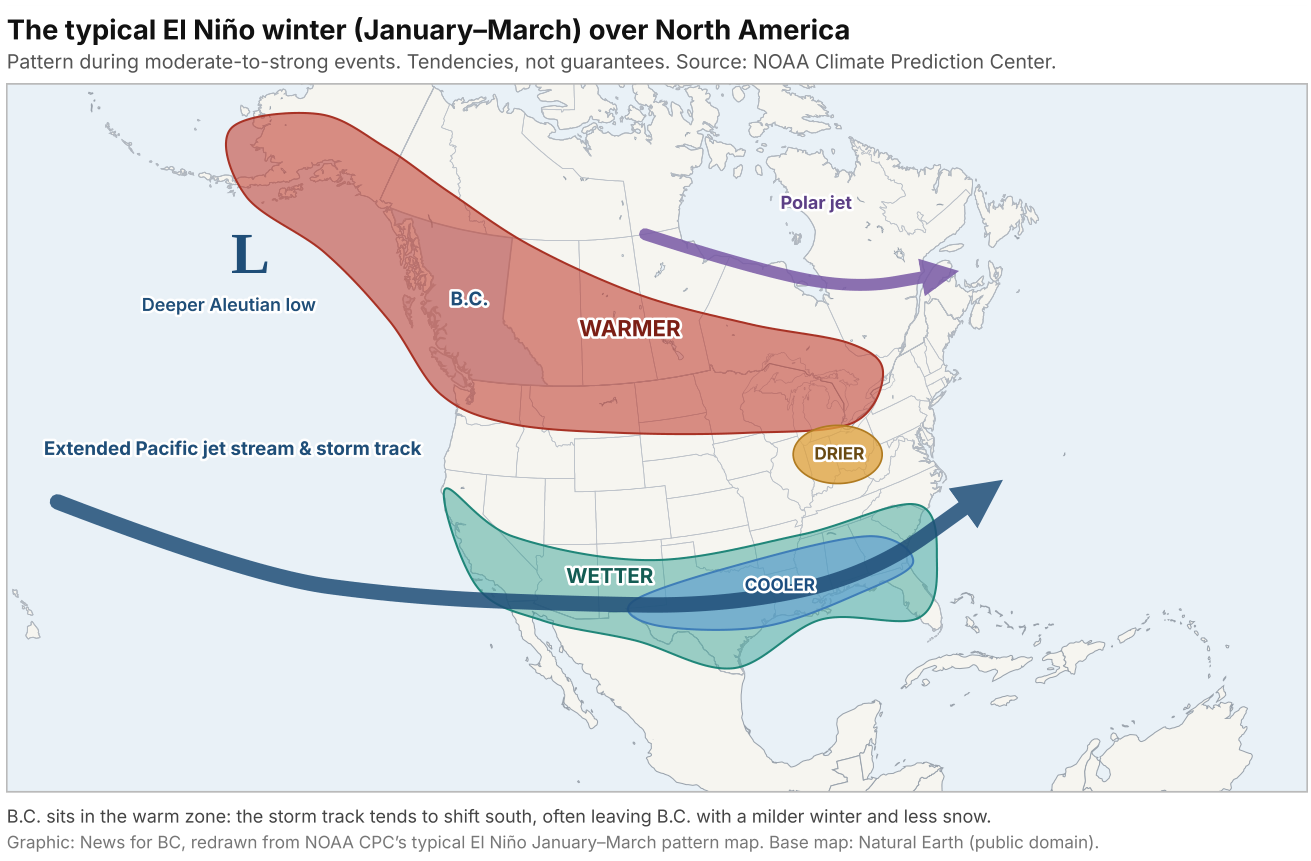
During moderate-to-strong El Niño winters, the Pacific jet stream and storm track tend to shift south across the U.S., leaving B.C. and much of southern Canada milder than normal. Individual winters vary. Source: NOAA Climate Prediction Center, "North American winter features" (typical January–March pattern, moderate-to-strong El Niño). Redrawn by News for BC. Base map: Natural Earth (public domain). Graphic: News for BC.
That nuance matters on the South Coast. "These two things together could spell an unusually low snowpack, especially on the coast," Merryfield told CBC's Daybreak North in August, because whether storms bring snow or rain there depends on which side of freezing they fall. UBC wildfire scientist Lori Daniels says El Niños "have historically brought warmer, wetter winters to southern B.C., with more rain than snow and lower snowpacks."
Current outlooks fit that pattern. ECCC's Oct. 1 seasonal forecast gives an 80 to 89 per cent chance of above-normal temperatures for October to December at stations from Victoria and Vancouver to Kelowna, Cranbrook, Prince George and Fort St. John. ECCC's Aug. 1 forecast for December to February favoured drier-than-normal conditions over the Rockies and the Okanagan. For March to May 2027, that forecast gave at least a 90 per cent chance of above-normal temperatures across most of western Canada.
There is one wild card. NOAA notes that the North Pacific is in a "fairly strong, negatively phased" Pacific Decadal Oscillation, unlike in 1982-83, 1997-98 and 2015-16, and that this "may dampen the typical impacts of a strong El Niño in certain areas," including the Pacific Northwest coast.
River Forecast Centre bulletins show the April 1 provincial snowpack was below normal in each of the four El Niño winters since 2015: 73, 91, 79 and 63 per cent. Low years happen in other winters too, such as 79 per cent after the La Niña winter of 2024-25.
FIGURE 5 · SNOWPACK IN EL NIÑO YEARS
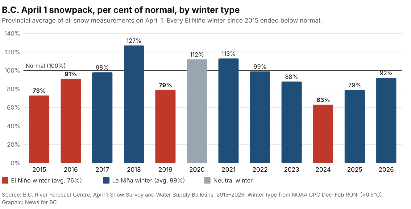
B.C.'s April 1 provincial snowpack, per cent of normal, 2015–2026. All four El Niño winters in this period ended below normal, but low years also follow other winters, such as 2025. Source: B.C. River Forecast Centre, April 1 Snow Survey and Water Supply Bulletins, 2015–2026; winter type from NOAA CPC December–February RONI values (±0.5°C). Graphic: News for BC.
What it means, sector by sector
Water supply and drought. The Okanagan Basin Water Board's September fact sheet warns that snowpack "will likely be low and melt early," raising "an elevated chance that drought conditions will continue into 2027." The province already used a fish-protection order on Aug. 28 to cut water use by 131 licence holders on Bessette Creek, where flows hit record lows in July. On Sept. 21, the province again urged communities to keep conserving.
Hydro power. In fiscal 2023-24, after drought and El Niño, BC Hydro's net electricity imports reached about 13,600 gigawatt-hours, roughly a fifth to a quarter of the province's supply, at a cost of nearly $1.4 billion, according to its filings with the B.C. Utilities Commission. Net imports fell to 8,356 GWh in 2024-25. A strong 2026 snowpack in the Peace and Upper Columbia led the utility to expect to be a net exporter this fiscal year. A thin 2027 snowpack would test that outlook.
FIGURE 6 · WHEN THE RESERVOIRS RUN LOW
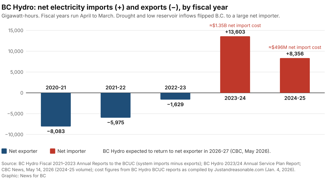
BC Hydro net electricity imports (positive) and exports (negative), gigawatt-hours, by fiscal year. Low inflows after the 2023 drought turned B.C. into a large net importer. Source: BC Hydro Fiscal 2021–2023 Annual Reports to the BCUC; BC Hydro 2023/24 Annual Service Plan Report; CBC News, May 14, 2026; cost figures from BC Hydro BCUC filings as compiled by Justandreasonable.com, Jan. 4, 2026. Graphic: News for BC.
Wildfire in 2027. As of Sept. 22, the BC Wildfire Service counted 477,521 hectares burned in 2026, below the 20-year average of about 530,000 hectares. ECCC's climate services centre links El Niño to "a greater burned area the following spring and summer," partly through more lightning. Daniels advises "early FireSmart preparation" ahead of summer 2027.
Agriculture and ranching. The 2026 drought has left B.C. ranchers short of hay. The BC Cattlemen's Association and Alberta Beef Producers set up a feed-matching line in September. Country Life in BC reported that the province's Production Insurance program had received 155 drought loss notices by Aug. 20, from 50 tree-fruit growers and 105 forage producers. A low-snow year would hit irrigation districts in the Okanagan, Similkameen and Thompson again. On the Prairies, ECCC's climate services centre warns of reduced spring runoff and soil moisture and a higher risk of "severe to extreme drought" where dryness already exists.
Forestry. Earlier melt and drier fuels could lengthen the fire season and its restrictions on industrial activity, while mild winters shorten the frozen-ground season northern operators rely on.
Mining. Mines depend on licensed water for ore processing and on stable conditions for tailings management. The Bessette Creek order, for example, temporarily barred water use for "processing ore." In the North, a warm El Niño winter delayed the opening of the Tibbitt to Contwoyto ice road, which serves N.W.T. diamond mines, to Feb. 12, 2024, according to the road's operator. Reuters reported that was about two weeks later than usual. Less snow can ease access and avalanche control at some sites, but means a poorer freshet for storage.
Fisheries and salmon. NOAA's marine heatwave tracker reported Sept. 30 that two large heatwaves are active in the northeast Pacific, one of them in the Gulf of Alaska. It expects coastal heat to move north as El Niño warming builds, "somewhat matching" 2015, when "The Blob" gave way to El Niño. UBC zoologist Christopher Harley notes that past El Niños have brought kelp declines and food shortages for seabirds and marine mammals. Low, warm rivers in 2027 would add stress for spawning salmon.
Ski and winter tourism. In December 2023, 90 mm of rain pushed Whitewater's opening back a week, and RED Mountain also delayed its start. Private forecaster OpenSnow's 2026-27 outlook favours below-average snowfall at Powder Highway resorts, including Whitewater, RED and Fernie, which are "more vulnerable to warm temperatures and higher snow levels." It says Okanagan resorts such as Big White "can do ok" when storms arrive from the south. It flags January as the most promising month.
Municipalities, insurance and food. Water restrictions are likely to start earlier in snow-fed systems. Insured losses from the 2023 Okanagan and Shuswap fires topped $720 million, B.C.'s costliest insured event, according to the Insurance Bureau of Canada. Globally, the UN-backed AMIS Market Monitor said in October that El Niño years have historically cut rice yields 1 to 1.5 per cent below trend. Rabobank has flagged cocoa, palm oil, robusta coffee, sugar and Australian grains as exposed. AMIS describes Australia's wheat crop as mixed so far, with exceptional conditions in South Australia and Victoria but dryness in Queensland and Western Australia. Peru's anchovy fishery has already been disrupted, pushing up the cost of fishmeal used in salmon farming.
Shipping and the economy. The BBC reports drought is again limiting Panama Canal traffic, and Rabobank warns low rivers could slow Brazilian grain shipments. For B.C. ports, the exposure is mainly global supply chains and freight costs.
Timeline: what to expect, and when
FIGURE 7 · THE YEAR AHEAD
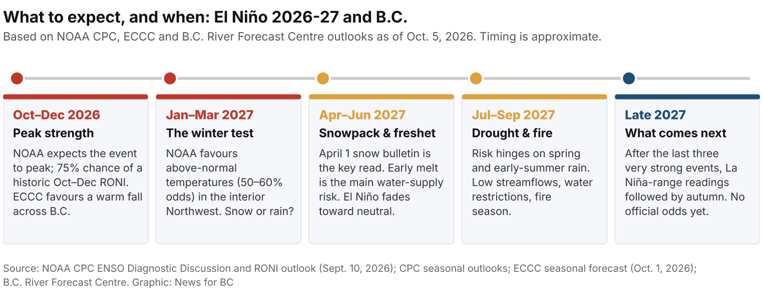
What to expect, from peak strength this fall to the possibility of La Niña in late 2027. Timing is approximate. Source: NOAA CPC ENSO Diagnostic Discussion and RONI outlook (Sept. 10, 2026); CPC seasonal outlooks; ECCC seasonal forecast (Oct. 1, 2026); B.C. River Forecast Centre. Graphic: News for BC.
- Now to December 2026: peak. NOAA expects the event to keep strengthening and peak in October to December. ECCC expects a warm fall across B.C.
- January to March 2027: the winter test. NOAA favours above-normal temperatures in the interior Pacific Northwest (50 to 60 per cent odds). Watch whether storms bring snow or rain to the South Coast and Interior.
- April to June 2027: freshet. NOAA's median forecast has the relative index falling to about +0.8°C by March to May, heading toward neutral. Early melt is the main risk to water supply.
- Summer 2027: drought and fire. Risk depends heavily on spring and early-summer rain.
- After that: La Niña? On NOAA's relative index, each of the last three very strong events was followed by La Niña-range readings by the next autumn. NOAA has not yet issued official odds for late 2027.
How to prepare
Households. Plan for watering restrictions and fix leaks now. Do FireSmart work, such as clearing roofs and gutters and creating a non-combustible zone around the home, during the fall and winter rather than in July. Check insurance for wildfire, smoke and overland water coverage. Assemble a grab-and-go kit.
Farmers and ranchers. Lock in hay and feed contracts early. The BC Cattlemen's "hay line" is 250- 306-6277. Review irrigation efficiency and on-farm storage; the Agriculture Water Infrastructure Program has funded more than 700 projects. Confirm Production Insurance and AgriStability coverage. The AgriService BC line is 1-888-221-7141.
Municipalities and water districts. Update drought and conservation bylaws before spring. Model supply under a 60 per cent snowpack scenario. Coordinate early with licence holders and First Nations on fish flows.
Mining and forestry operators. Stress-test water balances and tailings plans for low inflow. Confirm licence conditions and backup sources. Plan for a shorter winter-road and frozen-ground season, and prepare for fire-season restrictions in 2027.
Ski and tourism operators. Check snowmaking capacity and water rights. Build flexible opening dates and refund policies. Market high-elevation terrain and non-snow activities.
What to watch
- NOAA CPC ENSO update: Oct. 8, then usually the second Thursday of each month (Nov. 12, Dec. 10, Jan. 14).
- B.C. drought levels: next update Thursday, Oct. 8, on the province's Drought Information Portal.
- ECCC seasonal forecasts: issued at the start of each month.
- B.C. River Forecast Centre snow bulletins: based on the 2026 schedule, the Jan. 1 bulletin should come out around Jan. 9-12, 2027, followed by roughly Feb. 10-11, March 10-11 and April 9-10. The April 1 bulletin is the key one for summer water supply.
As Markovic put it: "Every El Niño is different than the previous one."
Sources
1. NOAA Climate Prediction Center, ENSO Diagnostic Discussion, Sept. 10, 2026 — https://www.cpc.ncep.noaa.gov/products/analysis_monitoring/enso_advisory/ensodisc.shtml
2. NOAA CPC, Official ENSO Strength Probabilities (RONI outlook), September 2026 — https://www.cpc.ncep.noaa.gov/products/analysis_monitoring/enso/roni/outlook/
3. NOAA CPC data: weekly Niño indices (wksst9120, rel_wksst9120), ONI and RONI tables — https://www.cpc.ncep.noaa.gov/data/indices/
4. NOAA CPC, Prognostic Discussion for Long-Lead Seasonal Outlooks (OND 2026 onward) — https://www.cpc.ncep.noaa.gov/products/predictions/long_range/fxus05.html
5. Australian Bureau of Meteorology, Climate Driver Update, Sept. 15, 2026 — https://www.bom.gov.au/climate/enso/
6. World Meteorological Organization, "El Niño set to become very strong, raising risks of extreme weather into 2027," Sept. 3, 2026 — https://public.wmo.int/news/media-centre/el-nino-set-become-very-strong-raising-risks-of-extreme-weather-2027
7. Copernicus Climate Change Service, Surface air temperature for August 2026 — https://climate.copernicus.eu/surface-air- temperature-august-2026
8. NOAA NCEI, Global Climate Report, August 2026 — https://www.ncei.noaa.gov/news/global-climate-202608
9. Canadian Centre for Climate Services / ECCC, "What the developing exceptional El Niño means for Canada in 2026-27," Aug. 21, 2026 — https://climatedata.ca/news/what-the-developing-exceptional-el-nino-means-for-canada-in-2026-27/
10. Environment and Climate Change Canada, seasonal temperature forecasts, Oct.–Dec. 2026 (issued Oct. 1, 2026) — https://weather.gc.ca/saisons/tableau_e.html?bc=det&product=fcstm0&season=03&type=temp
11. ECCC, Climate Trends and Variations Bulletin, Winter 2023/2024 — https://www.canada.ca/en/environment-climate- change/services/climate-change/science-research-data/climate-trends-variability/trends-variations/winter-2024-bulletin.html
12. CBC News, "Meteorologists are forecasting a 'super' El Niño. What does that mean for B.C.?" (Bill Merryfield interview), Aug. 16, 2026 — https://www.cbc.ca/news/canada/british-columbia/super-el-nino-british-columbia-9.7304763
13. My Media BC / CTV, interview with ECCC's Marko Markovic, Sept. 17, 2026 — https://mymediabc.ca/one-of-the-strongest-el-ninos- on-record-is-developing-what-could-it-mean-for-b-c-this-winter/
14. B.C. River Forecast Centre, Snow Survey and Water Supply Bulletins (1998, 2010, April 1 bulletins 2015–2026) and release schedule — https://www2.gov.bc.ca/gov/content/environment/air-land-water/water/drought-flooding-dikes-dams/river-forecast-centre/snow- survey-water-supply-bulletin
15. B.C. River Forecast Centre, 7-Day Streamflow Hazard Outlook, Oct. 1, 2026 — https://bcrfc.env.gov.bc.ca/outlooks/BC_7- Day_Streamflow_Hazard_Outlook.pdf
16. B.C. Ministry of Water, Land and Resource Stewardship, Bessette Creek fish-protection order (2026) — https://news.gov.bc.ca/releases/2026WLRS0046-000999
17. Okanagan Basin Water Board, "2026-2027 Super El Niño Fact Sheet," September 2026 — https://obwb.ca/wp- content/uploads/2026_09_ENSOFactSheet.pdf
18. BC Wildfire Service, Wildfire Season Summary (2023) — https://www2.gov.bc.ca/gov/content/safety/wildfire-status/about- bcws/wildfire-history/wildfire-season-summary
19. Trail Times, "B.C.'s fire season moderated by recent weeks of cool weather" (BCWS figures), Sept. 22, 2026 — https://trailtimes.ca/2026/09/22/b-c-s-fire-season-moderated-by-recent-weeks-of-cool-weather/
20. Global News, "BC Hydro imported a quarter of the province's power in the last 12 months," Nov. 28, 2024 — https://globalnews.ca/news/10892803/bc-hydro-imported-quarter-power-12-months/
21. CBC News, "B.C. Hydro expects return to being net electricity exporter," May 14, 2026 — https://www.cbc.ca/news/canada/british- columbia/bc-hydro-surplus-energy-exports-9.7198786
22. Castlegar News, BC Hydro Lower Columbia reservoir update, Sept. 25, 2026 — https://castlegarnews.com/2026/09/25/west- kootenay-welcomes-rain-as-basin-runoff-remains-below-normal/
23. CFJC Today, BC Cattlemen's Association / Alberta Beef Producers feed line, Sept. 17, 2026 — https://cfjctoday.com/2026/09/17/like- a-dating-site-ranchers-in-b-c-and-alberta-partnering-up-to-address-feed-shortages/
24. Country Life in BC, "Water restrictions collide with wildfire season," 2026 — https://www.countrylifeinbc.com/water-restrictions- collide-with-wildfire-season/
25. UBC Media Advisory, "UBC experts on 'Super El Niño'," Oct. 1, 2026 — https://news.ubc.ca/advisory/ubc-experts-on-super-el-nino/
26. NOAA Fisheries / IEA, California Current Marine Heatwave Tracker, updated Sept. 30, 2026 — https://www.integratedecosystemassessment.noaa.gov/regions/california-current/cc-projects-blobtracker
27. Insurance Bureau of Canada, Okanagan and Shuswap wildfire insured losses (2023) — https://www.newswire.ca/news- releases/okanagan-and-shuswap-area-wildfires-cause-over-720-million-in-insured-damage-809284630.html
28. AMIS Market Monitor No. 142, October 2026 — https://www.foodsecurityportal.org/sites/default/files/2026- 10/AMIS_Market_Monitor_October_2026.pdf
29. Food Ingredients First, "Rabobank warns of rising El Niño risks across food commodities," Aug. 11, 2026 — https://www.foodingredientsfirst.com/news/el-nino-food-commodity-market-risks.html
30. Trail Times, "Rain forces Whitewater Ski Resort to push back opening day," Dec. 6, 2023 — https://trailtimes.ca/2023/12/06/rain- forces-whitewater-ski-resort-to-push-back-opening-day/
31. OpenSnow, "2026-2027 Winter Forecast," Aug. 11, 2026 — https://opensnow.com/news/post/2026-2027-winter-forecast-preview
32. Tibbitt to Contwoyto Winter Road, road update, Feb. 5, 2024 — https://jvtcwinterroad.ca/tcwr-road-update-feb-05-2024/ ; Reuters, Mar. 30, 2024 — https://www.reuters.com/world/americas/canadas-mild-winter-disrupts-key-ice-road-remote-arctic-diamond- mines-2024-03-30/
33. Wine Growers BC / industry report, impact of January 2024 cold event — https://www.winebusiness.com/content/file/Impact_of_January_2024_Cold_Event_on_BC_Wine_Industry_-_Public_Release(1).pdf
34. Singh, D. et al. (2018), "Climate and the Global Famine of 1876–78," Journal of Climate 31 — https://journals.ametsoc.org/view/journals/clim/31/23/jcli-d-18-0159.1.xml
35. Huang, B. et al. (2020), "How Significant Was the 1877/78 El Niño?" Journal of Climate — https://repository.library.noaa.gov/view/noaa/46581
36. Callahan, C. and Mankin, J. (2023), "Persistent effect of El Niño on global economic growth," Science — https://www.science.org/doi/10.1126/science.adf2983 ; AP coverage — https://apnews.com/article/el-nino-costly-warming-trillions- weather-fef931ec1230713d10fe4dd2abc4cd93
37. Video background reviewed: BBC News (Aug. 21, 2026) https://www.youtube.com/watch?v=_xZCh8eDZFc ; BBC The Global Story (Sept. 28, 2026) https://www.youtube.com/watch?v=Ou5wECGoStc ; The Weather Network (Aug. 15, 2026) https://www.youtube.com/watch?v=0HPOKrhEyn0 ; Just Have a Think https://www.youtube.com/watch?v=0iclm3G_sho ; DW News (Aug. 22, 2026) https://www.youtube.com/watch?v=Dcl5Mn373Oc ; CNN (Aug. 4, 2026) https://www.cnn.com/2026/08/04/weather/video/record-strongest-el-nino-cli-hrzn
38. NOAA Coral Reef Watch, Daily 5km Sea Surface Temperature Anomaly product (v3.1), image for Oct. 4, 2026 — https://coralreefwatch.noaa.gov/product/5km/index_5km_ssta.php
39. NOAA CPC, ENSO Strength Probabilities (RONI), issued Sept. 10, 2026 — https://www.cpc.ncep.noaa.gov/products/analysis_monitoring/enso/roni/strengths/
40. NOAA CPC, "North American Winter Features" (typical El Niño and La Niña January–March patterns) — https://www.cpc.ncep.noaa.gov/products/analysis_monitoring/ensocycle/nawinter.shtml
41. BC Hydro, Fiscal 2021, 2022 and 2023 Annual Reports to the BCUC (system imports and exports) — https://www.bchydro.com/content/dam/BCHydro/customer-portal/documents/corporate/regulatory-planning-documents/regulatory- filings/reports/2021-08-30-bchydro-f21-annual-report.pdf ; https://www.bchydro.com/content/dam/BCHydro/customer- portal/documents/corporate/regulatory-planning-documents/regulatory-filings/reports/00-2022-08-31-bch-f22-ann-rpt-ff.pdf ; https://www.bchydro.com/content/dam/BCHydro/customer-portal/documents/corporate/regulatory-planning-documents/regulatory- filings/reports/2023-08-31-bch-f23-annual-report.pdf
42. BC Hydro, 2023/24 Annual Service Plan Report (net imports of 13,603 GWh) — https://www.bchydro.com/content/dam/BCHydro/customer-portal/documents/corporate/accountability-reports/financial- reports/annual-reports/2023-24-annual-service-plan-report-cs-5002.pdf
43. Justandreasonable.com (Richard Mason), "BC Hydro spent nearly $2 billion on imported electricity in two years," Jan. 4, 2026 — https://justandreasonable.com/bc-hydro-spent-nearly-2-billion-on-imported-electricity-in-two-years/
44. Natural Earth, 1:50m cultural and physical vectors (public domain), used as base map for Figure 4 — https://www.naturalearthdata.com/
Forecast figures are current as of Oct. 5, 2026. NOAA's next ENSO update is due Oct. 8, 2026; numbers will change as the event evolves.